To the northeast of Bourton on the Water, in an area now occupied by Gloucestershire Wildlife Trust’s Greystones Farm Nature Reserve, exists an archaeological site and scheduled ancient monument of considerable importance. Known by its ancient name of Salmonsbury, this large prehistoric earthwork has been the focus of human activity for 6,000 years starting in the late Neolithic period and continuing through the Bronze and Iron Ages, the Roman period and on into Anglo-Saxon times (5th to 6th century A.D.). Most notable are the late Iron Age ramparts which are similar to those at other Iron Age hillforts of the Cotswolds. Salmonsbury however is unusual in that it is located on relatively low ground between two rivers Windrush and Dikler but on a well-drained gravel spread, making it highly suitable for habitation and farming.
Real interest in the location first arose in the mid 19th century with the discovery there of a large number of mid Iron Age iron currency bars but a full understanding of the site came from excavations carried out by Dr D C Dunning and Mrs Helen O’Neil in the 1930s and later work by Mrs O’Neil. Thanks to Mrs O’Neil’s gift to Cheltenham museum of material from those excavations, The Wilson today holds an important assemblage of finds from Salmonsbury, especially pottery and metal objects, also documents, drawings and photographs. More recently, non-intrusive geophysical surveys have provided still more information about the site.
Mesolithic (about 8,000 B.C.)
That the area of Salmonsbury had a significance since the earliest times has been shown by excavations carried out in 2015 of an area close to, but just outside of, the north west corner of the main fortified area. Among other archaeological features of later date, the excavations revealed three large post holes set out in an arc. The make-up of the fills of the holes indicates that each wooden post was approximately half a metre in diameter and that the posts were up to 2 to 3 metres high. Sealed in the primary fill of two of the holes were charred fragments of hazelnut and hazel wood dateable by radiocarbon analysis to around 8,000 to 8,500 B.C. Such totem pole-type monuments dating from this time are very rare in Britain, the most notable being found at Stonehenge. One suggestion is that they marked a ceremonial site or a meeting place used during seasonal migrations.

Neolithic period (about 4,000 – about 2,500 B.C.)
During the course of excavations in 1931, a number of ditches were excavated in which were found sherds of Neolithic Mortlake and Peterborough ware pottery. More recent geophysical surveying has revealed a fuller picture of concentric ditches at the centre of the site. These have been tentatively identified as a Neolithic causewayed enclosure. Its purpose is unclear; it could represent a settlement, a cattle enclosure or just a meeting place.

The 1930s excavations at Salmonsbury had uncovered a number of pits and ditches in which were found flints and pottery from the late Bronze Age. Later excavations in 1972 outside the western entrance to the Iron Age camp however revealed a large circular ring ditch approximately 96 feet in diameter, the V-shaped ditch being almost 3½ metres wide at the top and 1½ metres deep. The ring ditch formed a complete circle without an entrance to the interior. There were no dateable finds from the ditch but the feature is similar to Bronze Age ring ditches discovered elsewhere in the Thames Valley and Oxford areas, mostly thought to have a ritual significance.

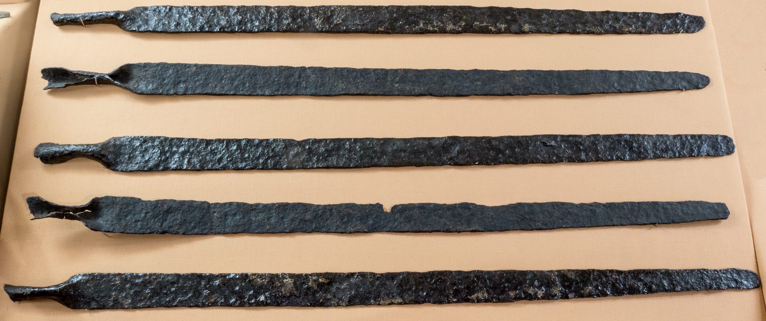
on display in the
Archaeology Gallery of The Wilson
Indications of settlement during the early-to-mid Iron Age have been noted at the Bourton on the Water primary school site, approx. 400 metres east of Salmonsbury, but that appears to have been abandoned in the 1st century B.C. when the settlement moved to the much larger site at Salmonsbury.
The site first came into prominence in 1860 with the significant discovery in its north-west corner of a hoard of 147 iron ‘currency bars’. Shaped like a sword blade with one end rounded-off and the other rolled and pinched, these objects are believed to have been used as units of distribution and exchange in the middle to late Iron Age. Similar examples have been found in a number of Iron Age sites in southern Britain. Five of these currency bars are held in The Wilson collection, others from the same hoard being held in various museums around the country including the British Museum.

found at Salmonsbury Camp.
Subsequent excavations of the site in the 1930s and later have shown that the settlement covers an area of around 56 acres/ 23 hectares and consists of double ramparts of gravel supported by dry stone walling, surrounding ditches and gateways on at least three sides . Excavation and geophysical surveys of the interior revealed a number of round houses (average diameter 6.7metres) with circular ditches for drainage, post holes for supporting conical thatched roofs and walls probably constructed of wattle and daub. Also revealed were enclosure ditches and storage pits. Finds include a wide range of locally and regionally produced pottery and some imported Gallo-Belgic wares, bone needles, handles for knives and spindle whorls . Human remains were found, as also were numerous animal bones of ox, goat, sheep and pig, indicating the availability of good food supply.
Although built with defensive ramparts, the low-lying site would not have been easily defended and the impression conveyed is of a fortified village built during relatively peaceful times such as would have been the case in a region at that time controlled by the dominant local Dobunni tribe.

A quantity of Roman pottery and coins dateable to the 4th century A.D, and evidence of Roman period structures, indicate that the Salmonsbury site was occupied during the Roman period but it also appears that the fortifications were being partly destroyed at this time. It has to be concluded therefore that the population there gradually moved to Romano-British settlement at nearby Bourton Bridge. This was established by the late 1st century A.D. and, being located on the Fosse Way – one of the country’s main arterial roads at the time – would have acted as a magnet to local populace.

While there is good evidence of Anglo-Saxon occupation in nearby Bourton, the only Saxon findings in Salmonsbury itself are of burials in or near the ramparts and there is no evidence of the site being used other than for agricultural purposes. The age-old prominence of the site was not forgotten by the Anglo Saxons though since in Domesday Book of 1086 the name Salmonsbury is used to denote the local Anglo Saxon Hundred and it is recorded elsewhere that meetings of the hundred court leet took place there.
In a Saxon Charter of 779 A.D., the placename Salmonsbury is given as ‘Sulmonnes burg’, which is interpreted as the ‘ploughman’s enclosure’, i.e. where he kept his oxen. It seems quite fitting therefore that the ancient monument of Salmonsbury, with all its fascinating history, is today officially preserved as a farm and nature reserve.
Share this article
Follow us
A quick overview of the topics covered in this article.


